
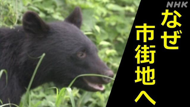
Damage to humans by bears has become an "abnormal situation" in many places.
On October 10, they broke through the glass door of the front door and broke into the house, and two women were attacked, causing a series of damage in places that should have been safe until now.
How do bears get out into inhabited areas? By overanalyzing sightings, traces, population, and topographic data, we were able to see "the route of the bear to the city" and "what is necessary to reduce damage".
table of contents
Bear sightings How many people live nearby?
How to get to the city center?
In addition to the "river", there are other bear routes
There are no rivers or forests, but there are bears...
"Bear damage is a 'disaster'" and "disaster mitigation is possible"
Open Table of Contents
table of contents
table of contents
Bear sightings How many people live nearby?
How to get to the city center?
In addition to the "river", there are other bear routes
There are no rivers or forests, but there are bears...
"Bear damage is a 'disaster'" and "disaster mitigation is possible"
Where are bears "sighted"?
This time, we focused on data on bear sightings.
In many prefectures where bears are infested one after another, information on bear sightings and traces received from local people is compiled and published on maps on the Internet.
"Kumapu" (Toyama Prefecture)
The purpose of the map is to call attention to it, but among them, the "Kumappu" published by Toyama Prefecture is updated frequently, and data for the past 10 years has been accumulated.
In Toyama Prefecture, two women were attacked and injured by a bear that invaded a house on October 10, and a 31-year-old woman was attacked and killed on the premises of a residential building on October 2.
With the permission of Toyama Prefecture, NHK analyzed the data on this map, a total of 17,79 pieces of information since 7.
We worked with experts to find out if we could get the clues we needed to prevent damage.
Sightings in urban areas
First, let's take a look at what kind of areas bears have been spotted in Toyama Prefecture.
Red: 2023 Light red: 2014-2022
Comparing the data from 2014 to last year (2022) with the data from Kotoshi (2023), Kotoshi was also spotted in the plains near the center of Toyama City.
More than ever, we can see sightings in or near urban areas.
When did it increase in urban areas?
This is as of October 10st.
Sightings and traces were scattered in mountainous and mountainous areas until the end of October.
It has also come to be seen in the urban areas of the plains.
The beeches in the mountains, which are food for bears, have had a bad harvest, and it seems that bears that tried to store nutrients for hibernation have come out to urban areas and nearby areas in October.
Also near schools, kindergartens...
There are many facilities where children gather, such as schools and kindergartens, in urban areas, and what about bear sightings near such facilities?
Yellow: Traces of sightings within 500 meters of a school, etc.
When we analyzed those within 500 meters of schools, there were 67 cases.
This means that 15% of all cases are found near children's facilities.
Bear sightings How many people live nearby?
From the data so far, it seems that more bear sightings and traces are being reported even in urban areas where many people live, but we will analyze and dig deeper into this with data.
We will use census population data that shows how many people live in the area, and we will overlay this with "sighting" and "trace" data.
In the map above, the darker the red, the more populated the area.
After all, it seems to be appearing in and around urban areas with large populations.
I also estimated the population around the point where there were "sightings" and "traces".
Estimate the population within a radius of 500 m from bear sightings and traces.
If we analyze the percentage of people who have more than 1000,<> people (the same level as the population density of Hiroshima City) and look at the changes from year to year.
Kotoshi had the highest rate at 8.3%.
It seems that it can be said that bears are coming out in areas where more people live.
(* As a characteristic of sighting/trace data, it is thought that the more populated areas are the more information about sightings and traces of one bear, so the results of the analysis may be stronger than the actual situation of bear infestation.)
"A bear that got lost eating in the mountains"
We asked Hisaaki Akaza of the Toyama Prefecture Nature Museum "Nei no Sato", who is conducting field surveys in detail about the ecology of bears, to look at the data so far.
"Nei no Sato" Hisaaki Akaza
Mr. Akaza said, "It is not surprising that beeches in the mountains are a bad crop, and they are looking for food and expanding their range of activity, and they are going deeper into people's living areas," and pointed out the movement of bears especially since the beginning of October.
"Until September, they managed to stay in the mountains, but when the hibernation season approached, they decided that they could not get enough nutrients to prepare for hibernation, so they began to step further and further toward the plains in search of food. I think this is a reflection of the trend of people getting lost in the mountains and going down to the plains in search of new places to eat," says
Hisaaki Akaza, Toyama Prefectural Natural Museum.
How to get to the city center?
On the other hand, the data also revealed the habits and behavior of bears.
Mr. Akaza's point was "river".
If you superimpose the location of the river on the map.
Light blue line: Class 1 and Class 2 rivers
You can see that there is a river flowing near the bears that have been confirmed in the built-up area.
There are tall bushes growing along the river, which means that it is one of the easiest routes for bears to move while hiding.
However, we also saw bear movements in places that are not necessarily along the river.
In addition to the "river", there are other bear routes
Between the plains and the mountainous areas of Toyama City, there is a belt of points that runs from east to west along the river, but there is also a separate belt heading north.
In order to know what kind of terrain this place is, let's overlay a map that expresses topographic data such as elevation and elevation difference at the site on the map.
It turns out that the strip to the north extends along a cliff-like terrain with a difference in elevation.
This terrain is called a "riparian terrace", and it is a terrain in which the river has carved the terrain over a long period of time, forming flat land and cliffs in a stepped pattern.
The flat land is used as a field and is touched by people, but the area around the cliff is difficult to use and the forest and forest spreads like a belt.
"These cliffs are also a good migration route for bears, and when bears appear, people tend to think that they are 'suddenly in an urban area,' but bears move while hiding in the riverbed of the river leading from the forest or in the forests of the river terraces to find food. There are many residential areas near the river, so there tends to be a lot of noise and damage. This is the same nationwide," says
Hisaaki Akaza, Toyama Prefectural Natural Museum "Nei no Sato"
There are no rivers or forests, but there are bears...
In addition, Mr. Akaza also says that "if there is no river or forest nearby, it is not safe."
What does that mean?
For example, in the rural area near the general sports park in Toyama City, there are no rivers or riverside terraces, but there are sightings and traces.
If you zoom in on the map.
Scattered in the fields were "scattered villages" surrounded by mansion forests.
It is a common sight in the plains of Toyama Prefecture.
"Scattered villages are like small forests, and even in places where there is no riverbed, it is thought that people move from one scattered village to the next while hiding themselves. It's not near the forest or the river, so it's no longer safe. Bears are not animals that we rarely encounter, and I think we should be vigilant because we think that it is natural to encounter them," says
Hisaaki Akaza of the Toyama Prefectural Natural Museum "Nei no Sato."
From the data, we can see that bears are approaching urban areas more than usual, using "rivers," "river terraces," and "scattered villages" as travel routes.
"Bear damage is a 'disaster'" and "disaster mitigation is possible"
What can we do now and what do we need to do in the future to avoid becoming a victim?
Based on what we found from the data analysis, we asked Mr. Akaza to point it out.
Toyama Prefectural Natural Museum "Nei no Sato" Hisaaki Akaza
"Now that there is a series of damages, bear damage is no longer as difficult as a natural disaster, and although it is difficult to completely prevent it, it is possible to reduce the damage by taking measures."
"Intermittent mowing of forests along rivers and river terraces can be effective, and while it is not 100% effective in preventing bears from moving, it can also put a burden on bears to move by not being able to hide. If you divide the area, it will be easier to search for bears when they appear, and if you can find bears early, you can reduce the damage."
"In addition, if you drop the fruits of persimmon trees that bears eat, you can shorten the time that bears stay in the area and reduce the probability of encountering people.
Details of usage data and analysis
▽ Data
used ▼ Sightings and trace data: "Kumappu" (Toyama Prefecture) ▼ Population data: 2020 census (e-stat) ▼ River data: National land numerical information (Ministry of Land, Infrastructure, Transport and Tourism) ▼ School data: National land numerical information (Ministry of Land, Infrastructure, Transport and Tourism)
▼ Topographic data: Color-coded elevation map (Geospatial Information Authority of Japan)
▽ Population estimation method:
Draw a circle with a radius of 500 m from the sighting and trace points, and intersect with the 500 m mesh data of the census. For each overlapping area, the population data of the census according to the area ratio is calculated, summed, and estimated.